

5 Days Backpacking Pictured Rocks
When my friend Abby Chatfield of Wanderlust Outfitters asked me to accompany her on a five-day, four-night backcountry scouting trip along Pictured Rocks National Lakeshore, I immediately obliged. Michigan’s upper peninsula is untamed and grand, and I don’t miss a chance to absorb its wild beauty. The UP is home to mountainous old-growth forests, more than 200 waterfalls, 4,300 inland lakes, 12,000 miles of streams, and 1,700 miles of shoreline along three great lakes. It has an untouched, last-frontier feeling that I just love.
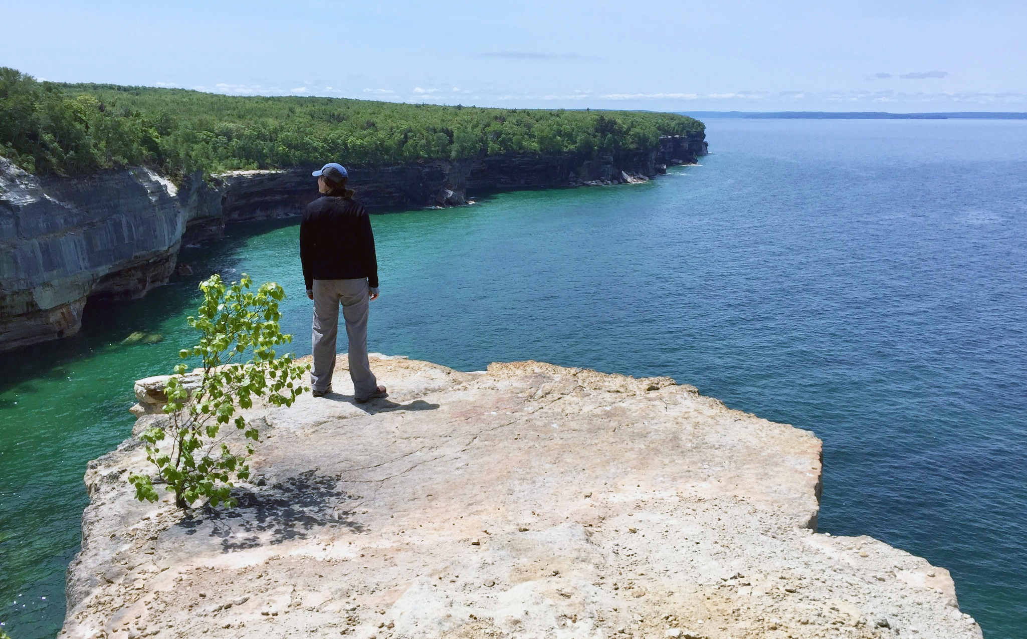
Becky Tranchell taking it all in.
About Pictured Rocks
Pictured Rocks National Lakeshore runs from Munising to Grand Marais, Michigan along Lake Superior’s south shore. It is known for its colorful cliffs and sweeping scenic vistas. It encompasses more than 100 miles of trails, towering sand dunes, sandy and rocky beaches, expansive views of sandstone cliffs bordering indigo and turquoise waters, and deep-green and sun-dappled forests. The area is a magnet for car-campers, day trippers, paddlers, and hikers alike.

Bright-eyed and clean before embarking on our four-day, three-night backcountry adventure from Grand Sable Visitor’s Center.
About Our Trip
We planned our trip for the first week in June 2018. When I say “we,” I mean Abby planned the entire trip. She was scouting for Wanderlust, where she guides adventure trips. (Check out their latest backpacking and paddling adventure trips on their Facebook page). I will share our itinerary and some tips, but Abby is the true mastermind behind the trip, and I relied heavily on her notes when writing this post.
We enjoyed prime conditions. It didn’t rain one droplet. The days were luxuriously long (dawn before 6am and twilight dwindling at close to 10pm). School wasn’t out for the summer, which meant we had the park largely to ourselves, and the weather still carried a cool bite (40-60 degrees F and windy), which kept black flies and mosquitos at bay.
Abby, our friend Becky, and I tackled 55 miles of hiking (42 miles along the North Country Scenic Trail plus a few of its spurs). We hiked through a wide variety of terrain—ranging from sandy beaches and rocky lakeside ridges to inland hardwood and old-growth hemlock forests. It was a largely flat hike with some rolling hills, but it packed punch. Around nearly every bend we were rewarded with a thrill: a waterfall, a towering sand dune, an endless view of cliff-bordered lakeshore, or a coppery tannic creek filled with trout.

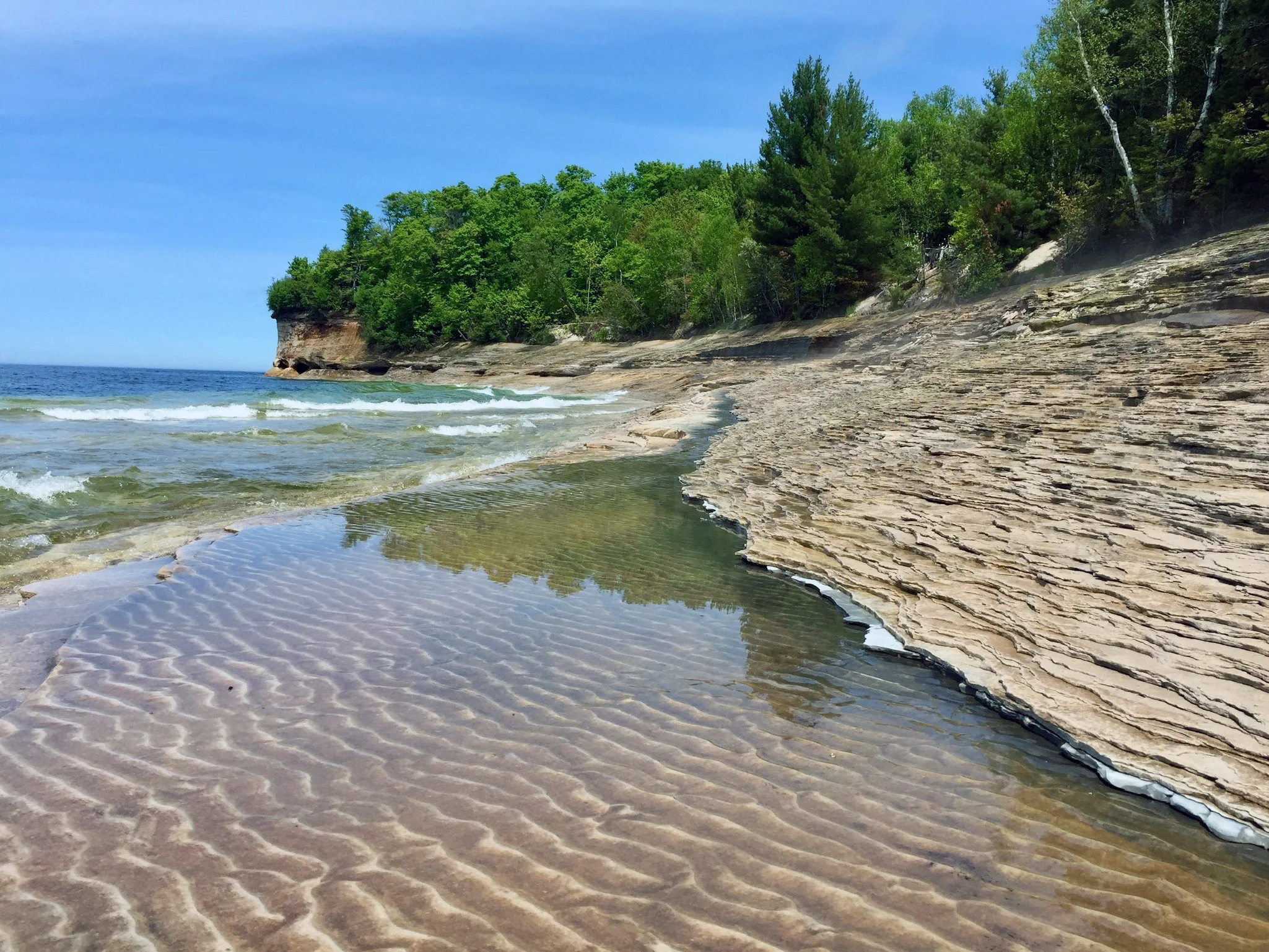
Colorful rocks on Lake Superior’s south shore.
It was an incredible five days spent listening to the gentle roar of Lake Superior, sleeping soundly after days in motion, and swapping the blue glow of an iPhone and a MacBook Pro for the deep greens and blues of the forest, lake, and sky. The culmination was a fitness challenge and detoxification more powerful than any yoga retreat, supplement blend, or juice cleanse combined.

Resting our feet at Sable Falls, one of 10 waterfalls we would see during our trip.
Preparing for the Trip
I’d only backpacked once before (one night on the Kalalau Trail in Kauai, Hawaii in college). So, I packed carefully, settling at 26lbs of meticulously arranged gear in a borrowed pack (Thanks Abby). I considered and reconsidered ideal trail snacks (macadamia nuts or almonds? tuna packs or jerky?). On the trail, I learned that I’d mostly crave water, cheddar cheese, and Sour Patch Kids.
I dug through every “outdoorsy” outfit I owned, ultimately opting for Abby’s (who has hiked the Appalachian Trail and was a hiking guide in Alaska) recommendation to bring one outfit (breathable jacket, rain coat, base layer, tee, and hiking pants), two pairs of wool socks and underwear, and one sports bra that’s lost most of its elasticity (maximum comfort, minimal chafing). In hindsight, my overall advice is that less is more when it comes to backpacking, and don’t forget the moleskin.
Tips if you’re planning your own trip:
· Reserve permits for backcountry campsites along your route ahead of time.
· Book a shuttle service to drive you from Munising Falls Visitor Center to Grand Sable Visitor Center. We started at Grand Sable and hiked back to our cars in Munising.
· Brush up on food handling best practices in bear country, and bring a way to hoist your foot up on bear poles (you’ll need rope and a food sack).
· Bring a water filter so you can take advantages of the creek and stream water sources you will find along the way.
· Check out the National Park Service’s latest planning resources for backcountry camping in Picture Rocks National Lakeshore.
The Itinerary
Day One: Day Hiking Near Munising (4.9 miles hiking)

Abby exploring behind Memorial Falls near Munising

Miners Falls near Munising
Day one included easy day hikes near Munising to wet our appetite for adventure. We took a scenic walk to the northside of Beaver Lake along Beaver Creek (3.2 miles of the Beaver Lake Loop) and explored two woodsy walks near waterfalls Miners Falls (1.2 miles) and Basin Trail and Sable Falls (0.5 miles).
We camped for the night at Munising Tourist Park Campground, a very clean, scenic campground directly on Lake Superior’s shore. We knew we needed rest, but I couldn’t sleep until I took in the entirety of the impressive tangerine and hot pink sunset that lit up the sky as we set up camp. Its vibrancy and brilliant shades of neon orange reminded me of the blazing sunsets that are common in the desert.

Sunset over Lake Superior from our Munising Tourist Park campsite.

Cream-colored, 300ft sand dunes for miles from the Log Slide Overlook
Day Two: Begin 3-Night Backcountry Camping Trip. Hike from Grand Sable Visitor Center to Sevenmile Creek Campground (17.5 miles hiking)
We started the morning on an 8am shuttle (not without a pre-shuttle stop for bagels at Bay Furnace Bagel Co. in Munising). We were giddy on the 1 hour and 15 minute shuttle ride up to our starting point, Grand Sable Visitor Center.
Our first day was our most epic in terms of both mileage and show-stopping views. (Full disclosure, we added several miles to our hike accidentally when we started our hike in the wrong direction Oops. I suppose that’s why you scout…)
One of the most magical things about hiking Pictured Rocks is the sheer diversity of landscape and the constant proximity to water. During our first day on the trail we witnessed pastoral landscapes, marshland, hardwoods, white pine stands, shoreline ridges, well-trodden dirt paths along beaches, expansive dune views, and old-growth hemlock forests. We also hit several of Pictured Rocks’ major landmarks: the Log Slide Overlook, the AuSable Light Station, and 12-mile Beach Campground.
We stirred up bald eagles, hiked through forest floors covered in 3-ft-tall ferns, took in lake views so expansive the curve of the horizon line visibly encircled us, and spotted marsh marigolds, lady slippers, and trillium along our path.

Becky hiking toward AuSable Light Station, where we would stop for lunch.
After 17.5 miles we finally swapped our hiking boots for Chacos and made camp at Sevenmile Creek Campground. (We passed several campgrounds throughout the day, if you want to plan a shorter first day and add a day to your trip). Luckily for our tired and hungry souls, other backpackers shared their already-built fire with us so that we could cook our dinners, hoist our food high up on the bear pole, and head to sleep. We slept heavily in a wooded campsite on a small hill above Sevenmile Creek.

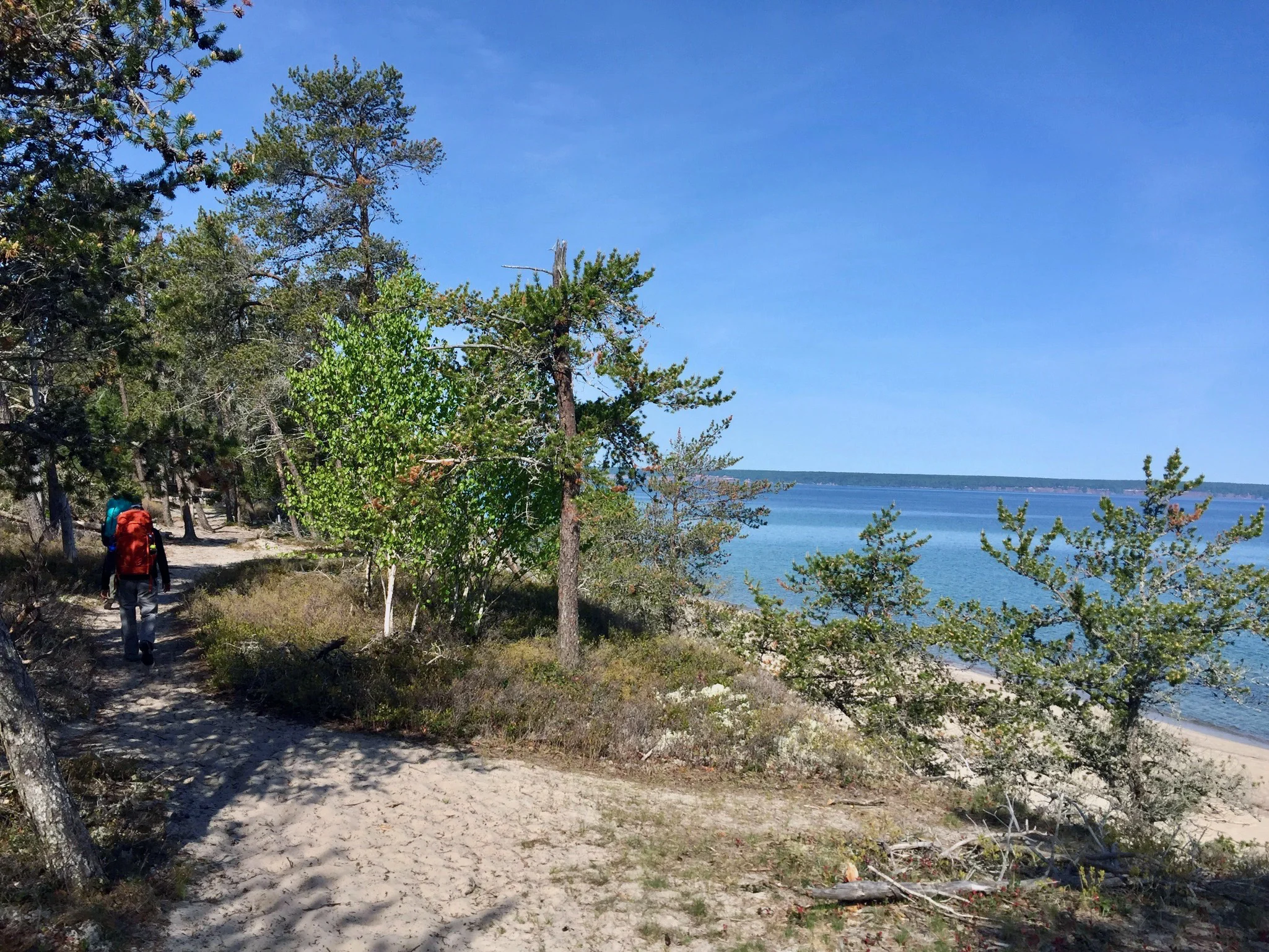
Abby trekking down to the lakeshore at Twelvemile Beach
Day 3: Hike from Sevenmile Creek to Chapel Beach + Trappers Lake Spur (14 miles of hiking)
After the show-stopping sites of our first day on the trail, our hike from Sevenmile Creek to Chapel Beach started slow in an inland woods. A highlight included happening upon a long-abandoned car that had decomposed down to rusty springs. Other passing hikers had etched their names in its faded blue paint. We stopped near it to take photos and stretch.
When we came upon the Trappers Lake Spur loop we ditched our packs to walk down to a breezy and peaceful inland lake, where we saw a snapping turtle sunbathing on a grassy log. We didn’t see much large wildlife besides a few deer, but we saw many chipmunks dart across our paths. We came to call them “microbears.”

Climbing down for a snack and (freezing-cold!) skinny dip.
Much of our journey on day three was in the Beaver Basin—a lower-lying area just east of where the land starts climbing to Pictured Rock’s famous multi-colored cliffs. We scaled a small sandy bluff down to Lake Superior’s shore to eat lunch. Droves of colorful agates, jasper, basalt, and others formed a mural of perfectly round red, black, white, and purple stones along the beach. Becky inspired us to dive into the frigid water. There, she earned her trail name, “dipper” for being the first to dive in and dipping three times, while Abby and I dove in once and immediately ran out.

Abby and Becky peeking over the sandstone cliffs.

Cool sandstone formations along Lake Superior.
We continued along the North Country Trail eastward, finding a hover of large trout as we crossed Beaver Creek, following a sandy path until we reached a landslide area where sandstone cliffs had collapsed in massive chunks in a cove with a small beach below. We found areas where we could descend small bluffs and walk onto mind boggling and beautiful sandstone ledges.

Moon walking along Lake Superior’s shore.

A good spot for a snack.
After exploring the surface-of-the-moon-like cove, we ascended into the cliffs area of the park. We took in sweeping views of painted cliffs topped with dense forest and Lake Superior stretching northward to the horizon. At the close of our day, we emerged from the woods to see the famous Chapel Rock.

Chapel Rock (note the white pine’s roots reaching back to the main land)
We camped at Chapel Beach campground, just beyond Chapel Rock, above Chapel Beach. This is one of the most beautiful places I’ve ever camped. In my heart, it was more luxurious than any 4-star beach resort. We set up our tents in a pine forest on a small bluff above the beach and climbed down to give our faces chilling splashes and ice-bath our feet before day four of our hike.

An empty Chapel Beach
Day 4: Hike from Chapel Beach to Potato Patch Campground, adding the Mosquito Falls Loop Enroute (11.6 miles of hiking)
Day four of the hike included some of the most stunning views of the Pictured Rock’s cliffs. Around each bend we were greeted by postcard-esque snapshots of the famous and magnificent lakeshore that you can only see by hiking. If you’re planning your trip specifically to see the cliffs, plan to do this stretch.

Epic views of Pictured Rock’s signature scenes between Chapel Beach and Potato Patch campground.

Hiking along Lake Superior’s shore
As a novice backpacker, I was hurting at this point in the trip. We had to be creative with moleskin and athletic tape to ease some of the tenderness. This was also the point in the trip that we slipped into a cadence in our hiking that was almost meditative as we hugged the lakeshore and watched streams spill out over the cliffside into Lake Superior.

Nurse Becky fixing up my wobbly and sore ankle for the day’s hike.
Potato Patch campground didn’t have a water source, so we filled several Platypus reservoirs at an earlier source and took turns carrying the extra weight for the remainder of the day. When we arrived at Potato Patch, I took the most majestic bathroom break I’ve ever taken. There was an exposed pit toilet in the middle of a meadow on an elevated platform. No walls for privacy—just the privacy of being 43 miles deep into a 3-day backcountry camping trip— and views of the meadow and the lake beyond the wooded ridge. I felt like queen of Potato Patch.

Sunset at Potato Patch
At the close of day four, setting up our tent and making dinner was methodical. We watched the sunset over the lake from the cliff top. I boiled water to pour over my freeze-dried dinner and ate it quickly, cross-legged in the dirt. Abby told us a story about eating seafood chowder in the company of a Grizzly in Alaska. As we ate, mosquitos started to creep in, so we hurried through our clean up and packed away our food bags and supplies in the campsite’s bear box.
Day 5: Hike from Potato Patch to Munising Falls (8.9 miles of hiking and drive home)
Our feet were throbbing, and our bones were weary, but this was the home stretch and our shortest hiking day of the trip. On our way in, we passed a few more of the parks major stunners, including Miners Castle, Miners Falls, and Sand Point.

A Pictured Rocks classic: Miners Castle
Hiking along Sand Point beach toward our final desintation, Munising Falls.
In the last several miles, the steady stream of conversation that had carried us through the trip dwindled and we focused on silently putting one foot in front of the other. As we walked along Sand Point beach, we saw a cluster of lime green kayaks bobbing in the breeze, enjoying the sunny day on Lake Superior.
We knew we were getting close to the end when we entered an area where people were day hiking from Munising Falls toward us. These day hikers smelled so clean, like they were drenched in perfume. It is wild how basic scents like detergent can become a foreign stench in just 4 days.
Our minds shifted back to the real world and our primary topic of conversation was where our first post-hike meal would be. We’d been talking about cravings all day (burgers, ice cream, nachos, and french fries topped the list).
When we rounded our final bend and walked through an anti-climactic parking lot to our cars, fresh clothes, face wipes, and flip flops were some of the first creature comforts we found. We enjoyed the view of Munising Falls from the viewing platform and smiled at our accomplishment.
In the end, the Pictured Rock’s hike is not about a challenging climb to a stunning summit, it is about remarkable beauty every step of the way.


